The Assessment of Environmental Impacts
On December 1, 2025 the Highway 413 draft Environmental Impact Assessment Report was released for comment. The comment period closed on January 6, 2026. We thank you for your interest and feedback on the Highway 413 Project. Comments provided during the comment period by the public, federal and provincial agencies, municipal representatives, Indigenous communities, and other interested persons will be reviewed and described in the final EIAR, anticipated to be released in early 2026.
The Environmental Impact Assessment Report covers the following elements:
Greenbelt and Agricultural Considerations
Ontario’s Greenbelt Plan recognizes the importance of infrastructure for people’s economic well-being, health and quality of life and it permits new projects provided they service the significant growth and economic development expected in southern Ontario. The province is committed to maintaining strong environmental oversight of Highway 413 to minimize impacts on natural terrain. Ontario is also taking steps to expand the Greenbelt to protect environmental, groundwater and agricultural resources for future generations.
The alignment of Highway 413 was chosen in part to reduce potential impacts to the Greenbelt while supporting long-term infrastructure needs. As the Project advances, the Ontario Ministry of Transportation (MTO) will carefully consider all impacts of Highway 413 and its construction. Key considerations, such as preserving the Credit and Humber rivers, informed early decisions to ensure major watercourses and their surrounding ecosystems are protected as much as possible. Watercourse crossings will be engineered to minimize disruption to natural systems, preserve fish habitat, reduce vegetation loss, and maintain local trail networks. Environmental stewardship and protection of Species at Risk remain core principles throughout the design and construction phases.
Protecting agricultural lands is also a top consideration. While a new transportation corridor cannot completely avoid impacting agricultural land, the Project Team will undertake an Agricultural Impact Assessment to help understand and minimize the impacts on the region’s agricultural land.
In the process for assessing impacts to the environment, the Project Team has undertaken significant data collection, fieldwork and analysis, evaluated alternatives, held numerous community and advisory group meetings, engaged and consulted with Indigenous communities and determined a Preferred Alignment. The following discipline studies are being carried out in support of the EIAR:
Completion of the Transportation Development Strategy (2012) included studying the area and looking at long-term modelling projections to determine if new road infrastructure was truly needed.
Building infrastructure responsibly
")
During the completion of the Transportation Development Strategy (2012), guidelines were developed to identify ways to minimize the impacts on the Greenbelt. The guidelines recommend the use of “green” infrastructure and planning, design and construction practices, such as:
- Community-sensitive design
- Consideration of impacts to ecology and wildlife
- Consideration of impacts to agriculture
- Stormwater management
- Designing features such as bridges to minimize environmental impacts
Environmentally-Friendly Practices and Technologies
Ontario is using and exploring environmentally-friendly practices and technologies while building major infrastructure projects, such as:
GreenPave
A system that rates asphalt and concrete pavement to assess its “greenness.” GreenPave promotes environmentally-responsible design and construction by encouraging the use of alternate fuels, local and recycled materials and reduces energy consumption, air pollutants, harmful emissions and more.
Tree Planting
Ontario supports programs that add new trees along highways and other infrastructure. For example, the Highway of Heroes program has planted nearly one million trees as a living tribute to Canada’s veterans, including more than 52,000 directly alongside Highway 401.
SmogStop Barriers
Ontario is exploring the use of noise barriers that are also designed to reduce air pollution. Emissions from vehicles are directed into channels where they react with a special photoreactive coating to reduce nitrogen oxides and volatile organic compounds into harmless by-products. The reaction is powered by sunlight and no electrical connections are required.
These methods and others like them can reduce the environmental impacts of Ontario’s major infrastructure projects like Highway 413.
Navigable Waterways
Plans for work in or around any navigable waterway may require authorization from Transport Canada.
A navigable waterway, as defined in the Canadian Navigable Waters Act (CNWA), is “a body of water, including a canal or any other body of water created or altered as a result of the construction of any work, that is used or where there is a reasonable likelihood that it will be used by vessels, in full or in part, for any part of the year as a means of transport or travel for commercial or recreational purposes, or as a means of transport or travel for Indigenous peoples of Canada exercising rights recognized and affirmed by section 35 of the Constitution Act, 1982, and
- there is public access by land or by water;
- there is no such public access, but there are two or more riparian* owners or
- His Majesty in right of Canada or a province is the only riparian owner.”
* Riparian refers to relating to or situated on the banks of a body of water.
Initial Screening
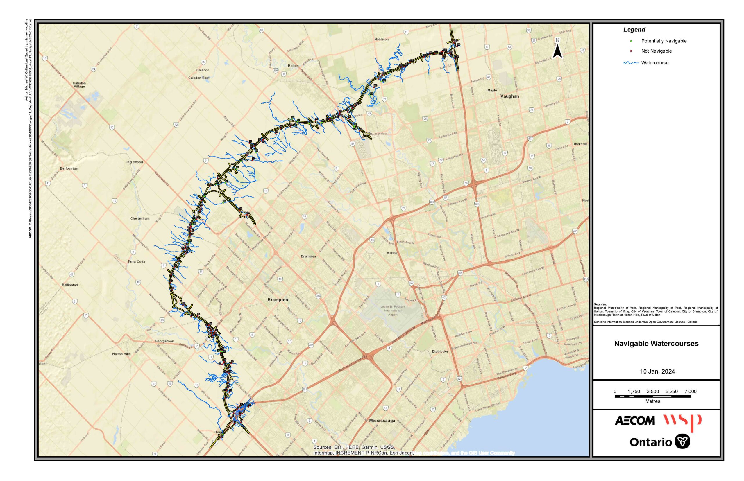
Within the Highway 413 Route, the Project Team has identified 24 stream or river locations that may be navigable.
As part of the assessment to initially determine the navigability of the watercourses crossing the proposed Highway 413, Hwy 410 and Hwy 427 extensions, fluvial geomorphic data (channel definition, hydraulic flow regime, and channel dimensions) were used to set the criteria for this initial assessment. This initial screening assessment is based on a previous navigable waters requirement that a channel must be at least 3.00 m wide and about 0.30 m deep across the channel.
The below mapping provides the results of this initial screening assessment. However, further consultation and field investigations will be needed to complete the assessment for the navigability of the initially screened water crossings. Please use the numbering on the map to identify the corresponding watercourse potentially used for navigation.